Our website is made possible by displaying online advertisements to our visitors.
Please consider supporting us by disabling your ad blocker.
Wolli Creek, New South Wales
| Wolli Creek Sydney, New South Wales | |||||||||||||||
|---|---|---|---|---|---|---|---|---|---|---|---|---|---|---|---|
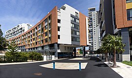
 Apartments on Brodie Spark Drive | |||||||||||||||
 | |||||||||||||||
| Population | 10,654 (2021 census)[1] | ||||||||||||||
| Established | 2002 | ||||||||||||||
| Postcode(s) | 2205 | ||||||||||||||
| Elevation | 5 m (16 ft) | ||||||||||||||
| Location | 10 km (6 mi) south of Sydney CBD | ||||||||||||||
| LGA(s) | Bayside | ||||||||||||||
| State electorate(s) | Rockdale | ||||||||||||||
| Federal division(s) | Barton | ||||||||||||||
| |||||||||||||||
Wolli Creek (formerly known as North Arncliffe) is a suburb in southern Sydney, in the state of New South Wales, Australia. It sits beside the Wolli Creek and Cooks River waterways. Wolli Creek is situated between the suburbs of Arncliffe and Tempe, 10 kilometres south of the Sydney central business district and is part of the St George area. Wolli Creek is in the local government area of Bayside Council.
- ^ Australian Bureau of Statistics (28 June 2022). "Wolli Creek". 2021 Census QuickStats. Retrieved 26 April 2022.
Previous Page Next Page


