Our website is made possible by displaying online advertisements to our visitors.
Please consider supporting us by disabling your ad blocker.
Woodlesford railway station
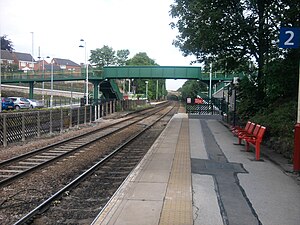
 Platform 2 in 2011, with the new footbridge from platform 1 | |||||
| General information | |||||
| Location | Woodlesford, City of Leeds England | ||||
| Coordinates | 53°45′25″N 1°26′37″W / 53.7570°N 1.4435°W | ||||
| Grid reference | SE368290 | ||||
| Managed by | Northern | ||||
| Transit authority | West Yorkshire Metro | ||||
| Platforms | 2 | ||||
| Other information | |||||
| Station code | WDS | ||||
| Fare zone | 2 | ||||
| Classification | DfT category F1 | ||||
| History | |||||
| Opened | 1 July 1840 | ||||
| Passengers | |||||
| 2019/20 | |||||
| 2020/21 | |||||
| 2021/22 | |||||
| 2022/23 | |||||
| 2023/24 | |||||
| |||||
| |||||
Woodlesford railway station serves a suburban village of Woodlesford and a town of Rothwell in West Yorkshire, England. It lies on the Hallam Line and the Pontefract Line, 6 miles (9.7 km) south of Leeds.
Previous Page Next Page


