Our website is made possible by displaying online advertisements to our visitors.
Please consider supporting us by disabling your ad blocker.
Wurm
| Wurm | |
|---|---|
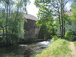
 Zwei Mühlen on the Wurm between Schloss Rimburg (D) and the village of Rimburg (NL) | |
 Course of the Inde, Wurm and Rur | |
| Location | |
| Country | Germany |
| State | North Rhine-Westphalia |
| Reference no. | DE: 2828 |
| Physical characteristics | |
| Source | |
| • location | South of Aachen |
| • coordinates | 50°44′15″N 6°05′16″E / 50.7374694°N 6.0877111°E |
| • elevation | 265 m above sea level (NN) |
| Mouth | |
• location | North of Heinsberg into the Rur |
• coordinates | 51°05′52″N 6°06′22″E / 51.0977°N 6.1062°E |
• elevation | 32 m above sea level (NN) |
| Length | 57.1 km (35.5 mi) [1] |
| Basin size | 355.518 km2 (137.266 sq mi) [1] |
| Basin features | |
| Progression | Rur→ Meuse→ North Sea |
| Landmarks |
|
The Wurm (German pronunciation: [vʊʁm]; Dutch: Worm [ˈʋɔr(ə)m]) is a river in the state of North Rhine-Westphalia in western Germany. It rises in the Eifel mountains and flows for 57 kilometres before discharging into the Rur.
Previous Page Next Page


