Our website is made possible by displaying online advertisements to our visitors.
Please consider supporting us by disabling your ad blocker.
Yekaterinoslav uezd
This article needs additional citations for verification. (August 2020) |
Yekaterinoslav uezd
Екатеринославскій уѣздъ | |
|---|---|
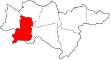
 Location in the Yekaterinoslav Governorate | |
| Country | Russian Empire |
| Governorate | Yekaterinoslav |
| Established | 1783 |
| Abolished | 1920 |
| Capital | Yekaterinoslav |
| Area | |
• Total | 7,858.31 km2 (3,034.11 sq mi) |
| Population (1897) | |
• Total | 357,207 |
| • Density | 45/km2 (120/sq mi) |
The Yekaterinoslav uezd[a] (Russian: Екатеринославский уезд, romanized: Yekaterinoslavsky uyezd; Ukrainian: Катеринославський повіт, romanized: Katerynoslavskyi povit) was one of the subdivisions of the Yekaterinoslav Governorate of the Russian Empire. It was situated in the western part of the governorate. Its administrative centre was Yekaterinoslav (present-day Dnipro).
Cite error: There are <ref group=lower-alpha> tags or {{efn}} templates on this page, but the references will not show without a {{reflist|group=lower-alpha}} template or {{notelist}} template (see the help page).
Previous Page Next Page


