Our website is made possible by displaying online advertisements to our visitors.
Please consider supporting us by disabling your ad blocker.
Zavodskyi District, Zaporizhzhia
Zavodskyi District
Заводський район | |
|---|---|
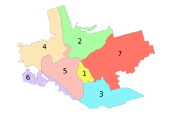
 Administrative map of Zaporizhzhia; the Zavodskyi Raion is indicated by the number 2. | |
| Coordinates: 47°53′50″N 35°11′35″E / 47.89722°N 35.19306°E | |
| Country | |
| Municipality | Zaporizhzhia Municipality |
| Established | 23 May 1969 |
| Government | |
| • Chairman | Volodymyr Biriuk[1] |
| Area | |
• Total | 56 km2 (22 sq mi) |
| Population (2012)[2] | |
• Total | |
| Time zone | UTC+2 (EET) |
| • Summer (DST) | UTC+3 (EEST) |
| Postal index | 330600 |
| Area code | +380 61 |
| KOATUU | 2310136600 |
| Website | w1 |
The Zavodskyi District (Ukrainian: Заводський район, Zavods'kyi raion) is one of seven administrative urban districts (raions) of the city of Zaporizhzhia, located in southern Ukraine. Its population was 60,390 in the 2001 Ukrainian Census,[3] and 52,191 as of 2012[update].[2]
- ^ "Zavodskyi District". Official portal (in Ukrainian). Site of the Zaporizhzhia City Government. Retrieved 25 January 2015.
- ^ a b "Number of the population of the City of Zaporizhzhia" (PDF) (in Ukrainian). State Statistics Service of Ukraine in Zaporizhzhia Oblast. 20 June 2012. Retrieved 25 January 2015.
- ^ "Zavodskyi District, Zaporizhzhia Oblast, City of Zaporizhzhia". Regions of Ukraine and their Structure (in Ukrainian). Verkhovna Rada of Ukraine. Retrieved 25 January 2014.
Previous Page Next Page


