Our website is made possible by displaying online advertisements to our visitors.
Please consider supporting us by disabling your ad blocker.
Zeya (river)
| Zeya | |
|---|---|
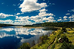
 Island on the Zeya. | |
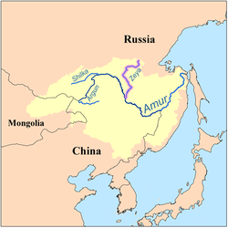
 Map of the Amur drainage basin with the Zeya highlighted | |
| Native name | Зея (Russian) |
| Location | |
| Country | Russia |
| Federal subject | Amur Oblast |
| Physical characteristics | |
| Source | Toko-Stanovik |
| Mouth | Amur |
• coordinates | 50°14′31″N 127°35′53″E / 50.2419°N 127.598°E |
| Length | 1,242 km (772 mi)[1] |
| Basin size | 233,000 km2 (90,000 sq mi)[1] |
| Discharge | |
| • location | Blagoveshchensk[2][1] |
| • average | 1,810 m3/s (64,000 cu ft/s) |
| • minimum | 1.5 m3/s (53 cu ft/s) |
| • maximum | 14,200 m3/s (500,000 cu ft/s) |
| Basin features | |
| Progression | Amur→ Sea of Okhotsk |
The Zeya (Russian: Зе́я; from indigenous Evenki word "djee" (blade); Chinese: 结雅; Manchu: ᠵᡳᠩᡴᡳᡵᡳ
ᠪᡳᡵᠠ, Mölendroff: jingkiri bira) is a northern, left tributary of the Amur in Amur Oblast, Russia. It is 1,242 km (772 mi) long, and has a drainage basin of 233,000 km2 (90,000 sq mi).[3] The average flow of the river is 1,810 m3/s (64,000 cu ft/s).[1]
- ^ a b c d "Amur-Heilong River Basin Reader" (PDF). ISBN 9789881722713.
- ^ Sokolov, Far East // Hydrography of USSR. (in Russian)
- ^ "Река ЗЕЯ in the State Water Register of Russia". textual.ru (in Russian).
Previous Page Next Page


