Our website is made possible by displaying online advertisements to our visitors.
Please consider supporting us by disabling your ad blocker.
Ver
| Ver | |||||||||||
|---|---|---|---|---|---|---|---|---|---|---|---|
| Frantziako udalerria | |||||||||||
 | |||||||||||
| Administrazioa | |||||||||||
| Estatu burujabe | |||||||||||
| Frantziaren banaketa administratiboa | |||||||||||
| Eskualdea | |||||||||||
| Departamendua | |||||||||||
| Barruti | Coutanceseko barrutia | ||||||||||
| Kantonamendu | canton of Gavray | ||||||||||
| Izen ofiziala | Ver | ||||||||||
| Posta kodea | 50450 | ||||||||||
| Geografia | |||||||||||
| Koordenatuak | 48°53′38″N 1°23′34″W / 48.8939°N 1.3928°W | ||||||||||
 | |||||||||||
 | |||||||||||
| Azalera | 13,27 km² | ||||||||||
| Altuera | 20 m eta 118 m | ||||||||||
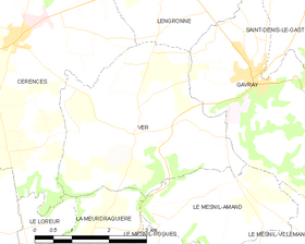
| Mugakideak | Lengronne, Cérences, Le Loreur, La Meurdraquière eta Gavray-sur-Sienne | ||||||||||
| Demografia | |||||||||||
| Biztanleria | 384 (2022ko urtarrilaren 1a) | ||||||||||
| |||||||||||
| Dentsitatea | 29 bizt/km² | ||||||||||
| Informazio gehigarria | |||||||||||
| Ordu eremua | UTC+01:00 eta UTC+02:00 | ||||||||||
Ver Frantziako udalerria da, Mantxa (departamendua)Mantxa departamenduan dagoena, Normandia eskualdean. 2013an 364 biztanle zituen.
Previous Page Next Page


