Our website is made possible by displaying online advertisements to our visitors.
Please consider supporting us by disabling your ad blocker.
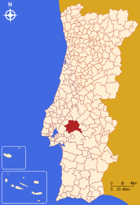
Coruche
| Coruche comune | |
|---|---|
 | |
| Localizzazione | |
| Stato | |
| Regione | Alentejo |
| Distretto | Santarém |
| Territorio | |
| Coordinate | 38°57′N 8°32′W |
| Superficie | 1 120 km² |
| Abitanti | 21 332 (2001) |
| Densità | 19,05 ab./km² |
| Comuni confinanti | Almeirim, Arraiolos (07), Benavente, Chamusca, Montemor-o-Novo (07), Montijo (15), Mora (07), Ponte de Sor (12), Salvaterra de Magos |
| Altre informazioni | |
| Cod. postale | 2100 |
| Prefisso | (+351) 243 |
| Fuso orario | UTC+0 |
| Subregione | Lezíria do Tejo |
| Cartografia | |
 | |
| Sito istituzionale | |
Coruche (ku'ɾuʃ(ɨ)) è un comune portoghese di 21 332 abitanti situato nel distretto di Santarém.
Previous Page Next Page


