Our website is made possible by displaying online advertisements to our visitors.
Please consider supporting us by disabling your ad blocker.
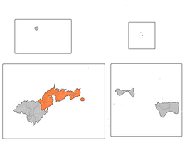
Distretto Orientale (Samoa americane)
| Distretto orientale distretto | |
|---|---|
| Eastern district | |
 | |
| Localizzazione | |
| Stato | |
| Territorio | |
| Coordinate | 14°16′S 170°39′W |
| Altitudine | 22 m s.l.m. |
| Superficie | 67,02 km² |
| Abitanti | 23 441 (2000) |
| Densità | 349,76 ab./km² |
| Altre informazioni | |
| Fuso orario | UTC-11 |
| Cartografia | |
 | |
Il distretto Orientale, in inglese Eastern district, è una delle tre suddivisioni amministrative di primo livello delle Samoa Americane; ha una superficie di 67,027 km² e, in base al censimento del 2000, 23.441 abitanti[1].
- ^ (EN) U.S. Department of Commerce, Economics and Statistics Administration e U.S. Census Bureau, Population and Housing Profile: 2000 - American Samoa - Eastern District (PDF), su Census.gov, maggio 2004, p. 7. URL consultato il 17 agosto 2018.
Previous Page Next Page


