Our website is made possible by displaying online advertisements to our visitors.
Please consider supporting us by disabling your ad blocker.
Rethel
| Rethel comune | |
|---|---|
(dettagli)
| |
 | |
| Localizzazione | |
| Stato | |
| Regione | Grande Est |
| Dipartimento | |
| Arrondissement | Rethel |
| Cantone | Rethel |
| Territorio | |
| Coordinate | 49°30′35″N 4°22′03″E |
| Altitudine | 67-146 m s.l.m. |
| Superficie | 18,6 km² |
| Abitanti | 8 103[1] (2009) |
| Densità | 435,65 ab./km² |
| Altre informazioni | |
| Cod. postale | 08300 |
| Fuso orario | UTC+1 |
| Codice INSEE | 08362 |
| Nome abitanti | Rethélois |
| Cartografia | |
 | |
| Sito istituzionale | |
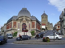
Rethel è un comune francese di 8 103 abitanti situato nel dipartimento delle Ardenne nella regione del Grande Est, sede di sottoprefettura.
Previous Page Next Page


