Our website is made possible by displaying online advertisements to our visitors.
Please consider supporting us by disabling your ad blocker.

Barlow (Derbyshire)
| Civil parish in Engeland | |||
|---|---|---|---|
 | |||
| Situering | |||
| Regio | East Midlands | ||
| Graafschap | Derbyshire | ||
| District | North East Derbyshire | ||
| Coördinaten | 53° 16' NB, 1° 29' WL | ||
| Algemeen | |||
| Oppervlakte | 15,6170 km² | ||
| Inwoners (2011) |
920 (59 inw./km²) | ||
| Overig | |||
| Postcode(s) | S18 | ||
| Grid code | SK345746 | ||
| Post town | DRONFIELD | ||
| ONS-code | E04002862 | ||
| Foto's | |||
.jpg)
| |||
| Barlow | |||
| |||
Barlow is een civil parish in het bestuurlijke gebied North East Derbyshire, in het Engelse graafschap Derbyshire met 920 inwoners.
-
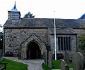 Kerk van St Lawrence

Zie de categorie Barlow, Derbyshire van Wikimedia Commons voor mediabestanden over dit onderwerp.
Geplaatst op:
9-8-2010
9-8-2010
Dit artikel is een beginnetje over landen & volken. U wordt uitgenodigd om op bewerken te klikken om uw kennis aan dit artikel toe te voegen.
Previous Page Next Page
Barlow (lungsod sa Hiniusang Gingharian, Inglatera, Derbyshire, lat 53,27, long -1,48) CEB Barlow, Swydd Derby CY Barlow, Derbyshire English Barlow (Derbyshire) French Barlow (Derbyshire) Italian Barlow (Derbyshire) LLD Barlow (Derbyshire) Polish Barlow, Derbyshire Swedish Barlow, Derbyshire Turkish Barlow (Derbyshire) ZH-MIN-NAN

