Our website is made possible by displaying online advertisements to our visitors.
Please consider supporting us by disabling your ad blocker.
North Ayrshire
| Raadsgebied van Schotland | |||
|---|---|---|---|
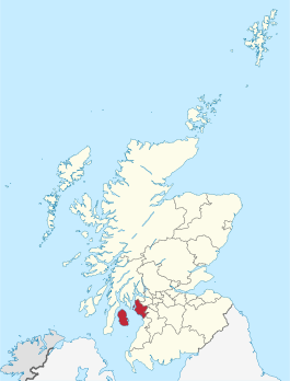
 Ligging van North Ayrshire in Schotland | |||
| Coördinaten | 55°40'0"NB, 4°47'0"WL | ||
| Algemeen | |||
| Oppervlakte | 885,4140[1] km² | ||
| Hoofdplaats | Irvine | ||
| - rang | 17e | ||
| Inwoners (2017) | 135.280 (153 inw./km²) | ||
| Politiek | |||
| Bestuur | |||
| MP's | Katy Clark, Brian Donohoe | ||
| MSP's | Irene Oldfather, Allan Wilson | ||
| Overig | |||
| ONS code | S12000021 | ||
| ISO 3166 | GB-NAY | ||
| Website | north-ayrshire.gov.uk | ||
| |||
North Ayrshire (Schots-Gaelisch: Sìorrachd Inbhir Air a Tuath) is een raadsgebied (council area) in het zuidwesten van Schotland met een oppervlakte van 885 km². De hoofdplaats is Irvine en het raadsgebied heeft 135.280 inwoners (2017).
Het raadsgebied omvat ook het eiland Arran, in het historische graafschap Buteshire, en enkele andere eilanden in de Firth of Clyde, waaronder Great Cumbrae. North Ayrshire behoort tot de lieutenancy area Ayrshire and Arran en, minus het eiland Arran tot het historische graafschap Ayrshire.
Previous Page Next Page


