Our website is made possible by displaying online advertisements to our visitors.
Please consider supporting us by disabling your ad blocker.
Kefar Zetim

| |
| Państwo | |
|---|---|
| Dystrykt | |
| Wysokość |
55 m n.p.m. |
| Populacja (2007) • liczba ludności |
|
Położenie na mapie Dystryktu Północnego  | |
Położenie na mapie Izraela  | |
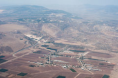
Kefar Zetim (hebr.: כפר זיתים) – moszaw położony w samorządzie regionu Ha-Galil ha-Tachton, w Dystrykcie Północnym, w Izraelu.
Leży na wschód od Jeziora Tyberiadzkiego w Dolnej Galilei.
Previous Page Next Page


