Our website is made possible by displaying online advertisements to our visitors.
Please consider supporting us by disabling your ad blocker.
Washington, D.C.
Washington, D.C. | |
|---|---|
| Destrict o Columbia | |
 Tap left: Healy Haw at Georgetoun Varsity; tap richt: U.S. Capitol; mids: Washington Monument; bottom left: Frederick Douglass Naitional Historic Site; bottom richt: African American Ceevil War Memorial | |
| Motto(s): Justitia Omnibus (Juistice for Aw) | |
 | |
| Coordinates: 38°53′42.4″N 77°02′12.0″W / 38.895111°N 77.036667°WCoordinates: 38°53′42.4″N 77°02′12.0″W / 38.895111°N 77.036667°W | |
| Kintra | Unitit States |
| Federal destrict | Destrict o Columbie |
| Appruivit | 16 Julie 1790 |
| Organisit | 1801 |
| Consolidatit | 1871 |
| Grantit limitit sel-govrenment | 1973 |
| Named for | George Washington |
| Govrenment | |
| • Mayor | Muriel Bowser (D) |
| • D.C. Council | Phil Mendelson (D), Convener |
| Area | |
| • Federal destrict | 177.0 km2 (68.3 sq mi) |
| • Laund | 159.0 km2 (61.4 sq mi) |
| • Water | 18.0 km2 (6.9 sq mi) |
| Elevation | 0–125 m (0–409 ft) |
| Population | |
| • Federal destrict | 672,228 |
| • Rank | 22nt, U.S. as o 2014[update] incorporatit places estimate |
| • Density | 4,251/km2 (11,011/sq mi) |
| • Metro | 6,033,737 (7t U.S.) |
| • CSA | 9546579 (4t U.S.) |
| • Demonym | Washingtonian |
| Time zone | UTC-5 (EST) |
| • Summer (DST) | UTC-4 (EDT) |
| ZIP code(s) | 20001-20098, 20201-20599 |
| Area code(s) | 202 |
| Website | www.dc.gov |
Washington, D.C. (pronounced /ˈwɒʃɪŋtən ˌdiːˈsiː/ (deprecatit template)), formally the Destrict o Columbie an commonly referred tae as Washington, the Destrict, or simply D.C., is the caipital o the Unitit States, foondit on Julie 16, 1790. Article Ane o the Unitit States Constitution provides for a federal destrict, clear frae the states, tae serve as the permanent naitional caipital. The Ceety o Washington wis oreeginally a separate municipality wi'in the federal territory till an act o Congress in 1871 establisht a single, unifeed municipal govrenment for the hale Destrict. It is for this raison that the ceety, while legally namit the Destrict o Columbie, is kent as Washington, D.C. Namit in honour o George Washington, the ceety skares its name wi the U.S. state o Washington locatit on the kintra's Paceefic coast.
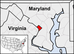
The Destrict is locatit on the north bank o the Potomac River an is surroondit bi the states o Virginia tae the soothwast an Maryland tae the ither sides. The ceety haes a resident population o 599,657; acause o commuters frae the surroondin suburbs, its population rises tae ower ane million durin the wirkweek. The Washington Metropolitan Aurie, o whilk the Destrict is a pairt, haes a population o 5.4 million, the aicht-lairgest metropolitan aurie in the kintra.
The centres o aw three brainches o the federal govrenment o the Unitit States are locatit in the Destrict, as are mony o the naition's moniments an museums. Washington, D.C. is hame tae 174 foreign embassies as weel as the heidquarters o the Warld Bank, the Internaitional Monetary Fund (IMF), the Organisation o American States (OAS), the Inter-American Development Bank, an the Pan American Healt Organisation (PAHO). The heidquarters o ither institutions sic as tred unions, lobbyin groups, an perfaisional associes are locatit in the Destrict forby.
Washington, D.C., is govrenit bi a mayor an a 13-memmer ceety cooncil. Housomiver, the Unitit States Congress haes supreme authority ower the ceety an mey owerturn local laws. Residents o the Destrict tharefore hae less sel-govrenance than residents o the states. The Destrict haes a nane-votin, at-muckle Congressional delegate, but nae senators. D.C. residents coud no vote in presidential elections till the ratification o the Twintie-third Amendment tae the Unitit States Constitution in 1961.
- ↑ "Table 1. Annual Estimates of the Resident Population for the United States, Regions, States, and Puerto Rico: April 1, 2010 to July 1, 2015" (CSV). U.S. Census Bureau. 22 December 2015. Retrieved 22 December 2015.
- ↑ "Annual Estimates of the Resident Population: April 1, 2010 to July 1, 2014 - United States -- Metropolitan Statistical Area; and for Puerto Rico". United States Census Bureau. 2015. Archived frae the original on 21 Mey 2015. Retrieved 12 Januar 2016.
Previous Page Next Page


