Our website is made possible by displaying online advertisements to our visitors.
Please consider supporting us by disabling your ad blocker.

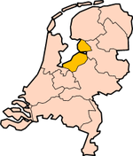
Flevoland
Flevoland | |
|---|---|
Province | |
.jpg) Oostvaardersplassen (municipality of Lelystad) | |
 Flag  Coat of arms | |
 Location | |
 Map | |
| Coordinates: 52°32′N 5°40′E / 52.533°N 5.667°E | |
| Country | Netherlands |
| Established | 1986 |
| Seat | Lelystad |
| Area | |
| • Total | 2,412 km2 (931 sq mi) |
| • Land | 1,410 km2 (540 sq mi) |
| • Water | 1,002 km2 (387 sq mi) |
| Highest elevation | 8 m (26 ft) |
| Lowest elevation | −5 m (−16 ft) |
| Population (2023) | |
| • Total | 445,000 |
| • Density | 315/km2 (820/sq mi) |
| Website | www |
Flevoland is one of the provinces of the Netherlands. Lelystad is its capital, but Almere is its biggest city. About 445,000 people are living in Flevoland (2023).
Location of the municipalities of Flevoland.
|
|

Previous Page Next Page

