Our website is made possible by displaying online advertisements to our visitors.
Please consider supporting us by disabling your ad blocker.
Fort Riley, Kansas
| Fort Riley | |
|---|---|
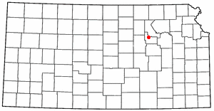
| Riley / Geary counties, near Junction City, Kansas | |
 Shoulder sleeve insignia of First Infantry Division | |
| Type | Army post |
| Site information | |
| Controlled by | United States |
| Site history | |
| Built | January, 1853 |
| In use | 1853–present |

Fort Riley is a United States Army installation in North Central Kansas. It is on the Kansas River between Junction City and Manhattan. The Fort Riley Military Reservation covers 101,733 acres (41,170 ha) in Geary and Riley counties.[1] The part of the fort that has housing development is part of the Fort Riley census-designated place. In 2010, 7,761 people lived there.[2] The fort has a daytime population of nearly 25,000. The ZIP Code is 66442.
- ↑ "Fort Riley Military Value Analysis Data; June 2014" (PDF). army.mil. Archived from the original (PDF) on 25 January 2017. Retrieved 31 March 2018.
- ↑ "Geographic Identifiers: 2010 Demographic Profile Data (G001): Fort Riley CDP, Kansas". American Factfinder. U.S. Census Bureau. Retrieved December 5, 2016.
Previous Page Next Page


