Our website is made possible by displaying online advertisements to our visitors.
Please consider supporting us by disabling your ad blocker.
Gulf of Carpentaria


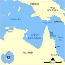
The Gulf of Carpentaria (14°00′S 139°00′E / 14.000°S 139.000°E) is a large, shallow sea surrounded on three sides by northern Australia. Its north edge is the Arafura Sea; the sea between Australia and New Guinea. At its mouth, the Gulf is 590 km wide, and further south, 675 km. The north south distance is more than 700 km. It covers a water area of about 300,000 km². The gulf is between 55 and 66 meters deep, although there are spots as deep as 82 meters.[1] In the last ice age the Gulf would have been dry land.
Previous Page Next Page


