Our website is made possible by displaying online advertisements to our visitors.
Please consider supporting us by disabling your ad blocker.
Jackson County, Kansas
Jackson County | |
|---|---|
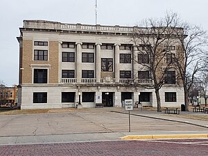
 Jackson County Courthouse (2023) | |
 Location within the U.S. state of Kansas | |
 Kansas's location within the U.S. | |
| Coordinates: 39°24′N 95°50′W / 39.400°N 95.833°W | |
| Country | |
| State | |
| Founded | February 11, 1859 |
| Named for | Andrew Jackson |
| Seat | Holton |
| Largest city | Holton |
| Area | |
| • Total | 658 sq mi (1,700 km2) |
| • Land | 656 sq mi (1,700 km2) |
| • Water | 1.8 sq mi (5 km2) 0.3% |
| Population | |
| • Total | 13,232 |
| • Density | 20.2/sq mi (7.8/km2) |
| Time zone | UTC−6 (Central) |
| • Summer (DST) | UTC−5 (CDT) |
| Congressional districts | 1st, 2nd |
| Website | jacksoncountyks.com |
Jackson County (county code JA) is a county in the U.S. state of Kansas. In 2020, 13,232 people lived there.[1] Its county seat is Holton. Holton is also the biggest city in Jackson County.[2] The county was first named Calhoun County. This was named after pro-slavery South Carolina Senator John C. Calhoun. The county was renamed in 1859 for President Andrew Jackson.[3] The Prairie Band Potawatomi Indian Reservation is in the county, and it makes up about 18.5% of the county's area.
- ↑ 1.0 1.1 "QuickFacts: Jackson County, Kansas". United States Census Bureau. Retrieved October 1, 2023.
- ↑ "Find a County". National Association of Counties. Archived from the original on May 31, 2011. Retrieved 2011-06-07.
- ↑ Gannett, Henry (1905). The Origin of Certain Place Names in the United States. Govt. Print. Off. p. 167.
Previous Page Next Page
مقاطعة جاكسون (كانساس) Arabic جکسون بؤلگهسی، کانزاس AZB Jackson County, Kansas BAR Джаксън (окръг, Канзас) Bulgarian জ্যাকশন কাউন্টি, ক্যানসাস BPY Jackson Gông (Kansas) CDO Джексон (гуо, Канзас) CE Jackson County (kondado sa Tinipong Bansa, Kansas) CEB Jackson County (Kansas) Czech Jackson County, Kansas CY


