Our website is made possible by displaying online advertisements to our visitors.
Please consider supporting us by disabling your ad blocker.
Jenin
Jenin | |
|---|---|
| Arabic transcription(s) | |
| • Arabic | جنين |
| • Latin | Jinin (official) Janin (unofficial) |
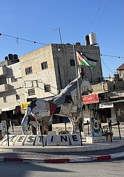
 The Jenin Horse sculpture in Jenin, Palestine (September 2023) | |
Location of Jenin within Palestine | |
| Coordinates: 32°27′40″N 35°18′00″E / 32.46111°N 35.30000°E | |
| Palestine grid | 178/207 |
| State | |
| Governorate | Jenin |
| Government | |
| • Type | City |
| • Head of Municipality | Hadem Rida |
| Area | |
| • Total | 37,342 dunams (37.3 km2 or 14.4 sq mi) |
| Population (2017)[1] | |
| • Total | 49,908 |
| • Density | 1,300/km2 (3,500/sq mi) |
| (plus 10,371 in Jenin refugee camp) | |
| Name meaning | The spring of gardens[2] |
Jenin (Arabic: جنين) is a city in the State of Palestine, in the Israeli-occupied West Bank. Jenin is a evidence of many periods of conflict and challenges faced by the Palestinians (such as displacement, raids by IDF), especially in the context of the Israel-Palestine conflict. Various political and social issues have affected the city and its residents over the years.
Jenin came under Israeli occupation in 1967, and was put under the administration of the Palestinian National Authority (PA) as Area A of the West Bank in 1993.[3]
- ↑ Preliminary Results of the Population, Housing and Establishments Census, 2017 (PDF). Palestinian Central Bureau of Statistics (PCBS) (Report). State of Palestine. February 2018. pp. 64–82. Retrieved 2023-10-24.
- ↑ Palmer, 1881, p. 147
- ↑ Assi, Seraj (5 July 2023). "Jenin's Long History of Defiance Against Israel and Its Occupation". Haaretz.
Previous Page Next Page


