Our website is made possible by displaying online advertisements to our visitors.
Please consider supporting us by disabling your ad blocker.
Niger River
 The Pont Kennedy across the Niger at Niamey in February 2019 | |
 | |
| Etymology | Unknown (possibly from Berber for River Gher or local Tuareg word n-igereouen meaning "big rivers"[1]) Or it may be a direct translation by Leo Africanus from Arabic bilād as-sūdān (بلاد السودان) "Land of the Blacks", into Latin (Niger "black").[source?] |
| Location | |
| Countries | |
| Cities | |
| Physical characteristics | |
| Source | |
| - location | Guinea Highlands, Guinea |
| - coordinates | 9°36′1.6848″N 10°51′52.3872″W / 9.600468000°N 10.864552000°W |
| Mouth | Atlantic Ocean |
| - location | Gulf of Guinea, Nigeria |
| - coordinates | 5°19′20.40″N 6°28′8.99″E / 5.3223333°N 6.4691639°E |
| Length | 4,184 km (2,600 mi) |
| Basin size | 2,117,700 km2 (817,600 sq mi) |
| Discharge | |
| - location | Niger Delta[2][3] |
| - average | 6,925 m3/s (244,600 cu ft/s)[3] 6,858.671 m3/s (242,211.7 cu ft/s)[4] |
| - minimum | 500 m3/s (18,000 cu ft/s) |
| - maximum | 27,600 m3/s (970,000 cu ft/s)[5] |
| Discharge | |
| - location | Lokoja |
| - average | 5,754.664 m3/s (203,224.0 cu ft/s)[4] |
| Discharge | |
| - location | Niamey |
| - average | 737.717 m3/s (26,052.2 cu ft/s)[6] |
| Discharge | |
| - location | Bamako |
| - average | 1,091.692 m3/s (38,552.7 cu ft/s)[7] |
| Basin features | |
| Tributaries | |
| - left | Sokoto River, Kaduna River, Benue River, Anambra River |
| - right | Bani River, Mékrou River |
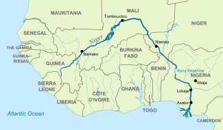
The Niger River [8] is the main river of western Africa. It is over 4180 km (2500 miles) long.
The river has a crescent shape and it goes through Guinea, Mali, Niger, on the border with Benin and then through Nigeria. Finally, it reaches the sea at a large delta, called the Niger Delta. This part of the Atlantic Ocean is called the Gulf of Guinea. The Niger is the third-longest river in Africa. Only the Nile and the Congo are longer. Its main tributary is the Benue River.
- ↑ "niger | Origin and meaning of the name niger by Online Etymology Dictionary". www.etymonline.com.
- ↑ "WWD Continents". www.geol.lsu.edu. Archived from the original on 8 October 2017. Retrieved 28 April 2018.
- ↑ 3.0 3.1 Prabhu TL (2021). "Agricultural Engineering: An Introduction To Agricultural Engineering". NestFame Creations Pvt. Ltd.
- ↑ 4.0 4.1 "Rivers Network". 2020. Archived from the original on 2022-08-09. Retrieved 2022-08-02.
- ↑ Castano, Ing. Antonio. "A STUDY ON THE HYDROLOGICAL SERIES OF THE NIGER RIVER AT KOULIKORO, NIAMEY AND LOKOJA STATIONS". webcache.googleusercontent.com. Archived from the original (PDF) on 1 January 2016. Retrieved 28 April 2018.
- ↑ "Rivers Network". 2020. Archived from the original on 2022-08-17. Retrieved 2022-08-02.
- ↑ "Rivers Network". 2020. Archived from the original on 2022-08-08. Retrieved 2022-08-02.
- ↑ /ˈnaɪdʒər/ NY-jər; French: (le) fleuve Niger, pronounced [(lə) flœv niʒɛʁ]
Previous Page Next Page


