Our website is made possible by displaying online advertisements to our visitors.
Please consider supporting us by disabling your ad blocker.
Parsons, Kansas
Parsons, Kansas | |
|---|---|
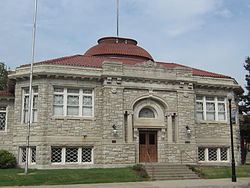
 Former Parsons Carnegie Library, now Parsons Carnegie Arts Center (2013) | |
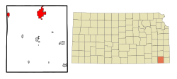
 Location within Labette County and Kansas | |
 | |
| Coordinates: 37°20′21″N 95°16′11″W / 37.33917°N 95.26972°W[1] | |
| Country | United States |
| State | Kansas |
| County | Labette |
| Founded | 1870 |
| Incorporated | 1871 |
| Named for | Levi Parsons |
| Area | |
| • Total | 10.72 sq mi (27.76 km2) |
| • Land | 10.63 sq mi (27.54 km2) |
| • Water | 0.09 sq mi (0.22 km2) |
| Elevation | 902 ft (275 m) |
| Population | |
| • Total | 9,600 |
| • Density | 900/sq mi (350/km2) |
| Time zone | UTC-6 (CST) |
| • Summer (DST) | UTC-5 (CDT) |
| ZIP code | 67357 |
| Area code | 620 |
| FIPS code | 20-54675 [1] |
| GNIS ID | 469782 [1] |
| Website | parsonsks.com |
Parsons is a city in Labette County, Kansas, United States. In 2020, 9,600 people lived there.[3] It is the biggest city in Labette County. It is the second biggest city in the southeastern region of Kansas.
- ↑ 1.0 1.1 1.2 1.3 "Parsons, Kansas". Geographic Names Information System. United States Geological Survey.
- ↑ Cite error: The named reference
CenPopGazetteer2020was used but no text was provided for refs named (see the help page). - ↑ 3.0 3.1 "QuickFacts: Parsons city, Kansas". United States Census Bureau. Retrieved November 29, 2023.
Previous Page Next Page


