Our website is made possible by displaying online advertisements to our visitors.
Please consider supporting us by disabling your ad blocker.
River Thames

The River Thames is a large river in England. It goes through London, the capital city of the United Kingdom.
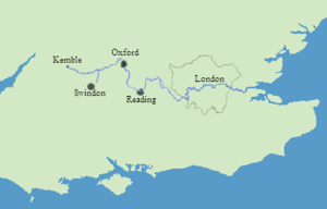
The Thames is 346 kilometres (235 statute miles) long. Its source is near the village of Kemble in the Cotswolds; it flows through Oxford (where it is called "The Isis", a shortening of its Latin name), Reading, Maidenhead, Eton and then Windsor.
From the outskirts of Greater London, it passes Syon House, Hampton Court Palace, Richmond (with the famous view of the Thames from Richmond Hill), and Kew. It then passes through London, then Greenwich and Dartford before it enters the sea in an estuary, The Nore. Part of the area west of London is sometimes called the Thames Valley. The area east of Tower Bridge is called Thames Gateway by development agencies and officials.
About 90 kilometres from the sea, above London, the river begins to show the tide caused by the North Sea. It is said that London was made capital of Roman Britain at the spot where the tides reached in 43 AD, but different things have pushed this spot farther up the river in the over 2000 years since then. At London, the water is slightly salty with sea salt.
Previous Page Next Page


