Our website is made possible by displaying online advertisements to our visitors.
Please consider supporting us by disabling your ad blocker.
Rust Belt

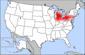
The Rust Belt is a term that refers to an area of the northern United States. The area is mostly the states near the Great Lakes, and some of them are considered to be Midwest states. This area was once known for steel production and heavy industry. That industry has greatly decreased since the middle of the 20th century. As the name might imply, the area has sort of turned to "rust", like what happens to old steel. Much of this decrease in industry is because of the United States using manufacturers from other countries. It became an Industrial hub because of its proximity to The Great Lakes, canals, and rivers which companies used to access raw materials and ship out products.
Most Rust Belt cities, for example, Pittsburgh, Pennsylvania and Youngstown, Ohio, have had a very large decrease in their population since the 1950s and 1960s.
Some "Rust Belt" cities include:
- Pittsburgh, Pennsylvania
- Erie, Pennsylvania
- Bethlehem, Pennsylvania
- Youngstown, Ohio
- Canton, Ohio
- Cleveland, Ohio
- Steubenville, Ohio
- Toledo, Ohio
- Columbus, Ohio
- Gary, Indiana
- Flint, Michigan
- McKeesport, Pennsylvania
- Wheeling, West Virginia
- Detroit, Michigan
- Milwaukee, Wisconsin
- Buffalo, New York
- Rock Island, Illinois
- Niagara Falls, New York
- Rochester, New York
- Grand Rapids, Michigan
- South Bend, Indiana
- Chicago, Illinois
- Charleston, West Virginia
- St. Louis, Missouri
- Camden, New Jersey
- Trenton, New Jersey
- Lansing, Michigan
- Newark, New Jersey
- Jersey City, New Jersey
- Fort Wayne, Indiana
- Springfield, Illinois
- Watertown, New York
- Akron, Ohio
- Warren, Ohio
- Ann Arbor, Michigan
- Harrisburg, Pennsylvania
- Scranton, Pennsylvania
- Anderson, Indiana
Previous Page Next Page


