Our website is made possible by displaying online advertisements to our visitors.
Please consider supporting us by disabling your ad blocker.
Taurus Mountains

- For the Taurus Mountains on the moon, see Montes Taurus. For Mount Taurus outside Cold Spring, New York, see Bull Hill.
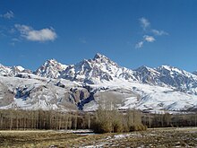
Taurus Mountains (Turkish: Toros Dağları) are a mountain range in Turkey, from which the Euphrates (Turkish: Fırat) and Tigris (Turkish: Dicle) descend into Syria and Iraq. The Manavgat River comes from its southern slopes.[1]

The mountain range extends along a curve from Lake Eğirdir in the west to the upper reaches of the Euphrates and Tigris in the east. It has many peaks rising above 10,000–12,000 ft (3,000–3,700 m), with the Demirkazık summit in the region known as Aladağlar, at 3,756 meters (12,322 ft.) as the highest point. Another important peak is Medetsiz (3,524 m/11,561 ft) in the Bolkar Dağları section.
This mountain range divides the Mediterranean region of southern Turkey from the central plateau.
Limestone has eroded to form karstic landscapes of waterfalls, underground rivers, and the largest caves of Asia.
At Kestel is a Bronze Age archaeological site where early evidence of tin mining was found.
- ↑ "Manavgat River Water as a Limited but Alternative Water Resource for Domestic Use in Middle East" (PDF). Archived from the original (PDF) on 2008-02-27. Retrieved 2008-02-16.
Previous Page Next Page


