Our website is made possible by displaying online advertisements to our visitors.
Please consider supporting us by disabling your ad blocker.
Wakayama Prefecture
Wakayama
和歌山県 | |
|---|---|
| Japanese transcription(s) | |
| • Romaji | Wakayama-ken |
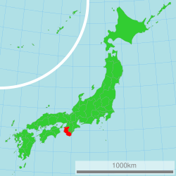
 Location of Wakayama in Japan | |
| Coordinates: 34°13′33.7″N 135°10′3.0″E / 34.226028°N 135.167500°E | |
| Country | |
| Region | Kansai |
| Island | Honshū |
| Capital | Wakayama |
| Government | |
| • Governor | Shuhei Kishimoto |
| Area | |
| • Total | 4,725.67 km2 (1,824.59 sq mi) |
| • Rank | 30th |
| Population (April 1, 2012) | |
| • Total | 989,983 |
| • Rank | 39th |
| • Density | 210/km2 (540/sq mi) |
| ISO 3166 code | JP-30 |
| Prefectural flower | Ume blossom (Prunus mume) |
| Prefectural tree | Ubame oak (Quercus phillyraeoides) |
| Prefectural bird | Japanese white-eye (Zosterops japonica) |
| Number of districts | 6 |
| Number of municipalities | 30 |
| Website | www.wakayama.lg.jp/ english/ |
Wakayama Prefecture (和歌山県, Wakayama-ken) is a prefecture in the Kansai region of Japan on the island of Honshū.[1] The capital is the city of Wakayama.[2] Wakayama Prefecture is surrounded by Osaka Prefecture, Nara Prefecture, Mie Prefecture, Hyogo Prefecture and Tokushima Prefecture.
- ↑ Nussbaum, Louis-Frédéric. (2005). "Wakayama prefecture" in Japan Encyclopedia, p. 1026; "Kansai" at p. 477.
- ↑ Nussbaum, "Wakayama" at p. 1025.
Previous Page Next Page


