Our website is made possible by displaying online advertisements to our visitors.
Please consider supporting us by disabling your ad blocker.
Alberto de Agostini National Park
| Alberto de Agostini National Park | |
|---|---|
 | |
| Location | Magallanes Region, Chile |
| Nearest city | Punta Arenas |
| Coordinates | 54°44′57″S 70°26′23″W / 54.74906°S 70.43967°W |
| Area | 1,460,000 ha (3,607,739 acres)[1] |
| Established | January 22, 1965[2] |
| Governing body | National Forest Corporation (Chile) |
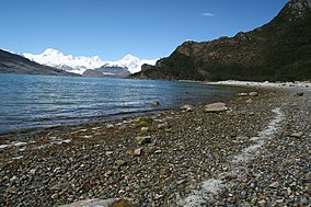
Alberto de Agostini National Park (Spanish pronunciation: [alˈβeɾto ðe aɣosˈtini]) is a protected area that was created on January 22, 1965,[2] on land that was formerly part of the "Hollanda" forest reserve and "Hernando de Magallanes National Park". It covers 1,460,000 hectares (3,607,739 acres)[1] and includes the Cordillera Darwin mountain range, which is the final land-based stretch of the Andes before it becomes a chain of mountains appearing as small islands that sink into the Pacific Ocean and the Beagle Channel.
The park, along with Cabo de Hornos National Park, was designated a Biosphere Reserve by UNESCO in 2005. As part of the Magallanes Sub-Polar (or Sub-Antarctic) Evergreen Rainforest, UNESCO highlights the area’s "mosaic of contrasting ecosystems and unique and singular characteristics on a world level."[3]
Several tidewater glaciers and steep fjords can be found in the park. It also comprises the Gordon, Cook and Londonderry islands, as well as part of Hoste Island (excluding the Hardy Peninsula and other portions).
- ^ a b "National Parks of Chile". CONAF. Retrieved 2 April 2017.
- ^ a b "Alberto de Agostini National Park". CONAF. Retrieved 2 April 2017.
- ^ Biosphere Reserve of the Magallanes Sub-Polar region UNESCO 2009–2014 retrieved on January 07, 2015
Previous Page Next Page
Нацыянальны парк Альберта дэ Агасціні BE Nationalpark Alberto de Agostini German Parque nacional Alberto de Agostini Spanish پارک ملی آلبرتو ده آگوستینی FA Parc national Alberto de Agostini French Parco nazionale Alberto de Agostini Italian ალბერტო-დე-აგოსტინის ეროვნული პარკი KA Alberto de Agostinio nacionalinis parkas LT Alberto de Agostini nacionālais parks Latvian/Lettish Alberto de Agostini nasjonalpark NN


