Our website is made possible by displaying online advertisements to our visitors.
Please consider supporting us by disabling your ad blocker.
Arthabaska Regional County Municipality
You can help expand this article with text translated from the corresponding article in Spanish. (June 2015) Click [show] for important translation instructions.
|
Arthabaska | |
|---|---|
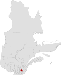
 Location in Quebec | |
| Coordinates: 45°55′N 72°05′W / 45.917°N 72.083°W[1] | |
| Country | Canada |
| Province | Quebec |
| Region | Centre-du-Québec |
| Effective | January 1, 1982 |
| County seat | Victoriaville |
| Government | |
| • Type | Prefecture |
| • Prefect | Lionel Fréchette |
| Area | |
• Total | 1,910.60 km2 (737.69 sq mi) |
| • Land | 1,890.18 km2 (729.80 sq mi) |
| Population (2016)[3] | |
• Total | 72,014 |
| • Density | 38.1/km2 (99/sq mi) |
| • Change 2011-2016 | |
| • Dwellings | 33,483 |
| Time zone | UTC−05:00 (EST) |
| • Summer (DST) | UTC−04:00 (EDT) |
| Area code | 819 |
| Website | www |
| [4] | |
Arthabaska Regional County Municipality (French pronunciation: [aʁtabaska]) is a regional county municipality located in the Centre-du-Québec region of Quebec. Its seat is Victoriaville.[2]
- ^ Cite error: The named reference
toponymiewas invoked but never defined (see the help page). - ^ a b c "Répertoire des municipalités: Geographic code 390". www.mamh.gouv.qc.ca (in French). Ministère des Affaires municipales et de l'Habitation.
- ^ a b "Census Profile, 2016 Census: Arthabaska, Municipalité régionale de comté [Census division], Quebec". Statistics Canada. Retrieved November 26, 2019.
- ^ "Arthabaska Regional County Municipality (Code 2439) Census Profile". 2011 census. Government of Canada - Statistics Canada.
Previous Page Next Page


