Our website is made possible by displaying online advertisements to our visitors.
Please consider supporting us by disabling your ad blocker.
B3 road (Namibia)
You can help expand this article with text translated from the corresponding article in German. Click [show] for important translation instructions.
|
| B3 road | ||||
|---|---|---|---|---|
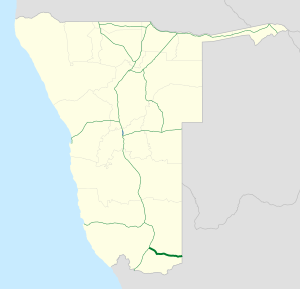
 Map of the B3. | ||||
| Route information | ||||
| Maintained by Roads Authority Namibia | ||||
| Length | 179 km (111 mi) | |||
| Major junctions | ||||
| East end | ||||
| West end | ||||
| Location | ||||
| Country | Namibia | |||
| Towns | Ariamsvlei, Karasburg | |||
| Highway system | ||||
| ||||
B3 is a national highway of Namibia. It passes through the ǁKaras Region of Namibia in the south for 179 kilometres (111 mi), connecting the B1 at Grünau to the South African border at Nakop via the town of Karasburg. In South Africa the highway continues as the N10 towards Upington.[1]
- ^ "Henties Bay Tourist Information". 2010-11-19. Archived from the original on 2010-11-19. Retrieved 2022-11-05.
Previous Page Next Page


