Our website is made possible by displaying online advertisements to our visitors.
Please consider supporting us by disabling your ad blocker.
Biggs Junction, Oregon
Biggs Junction, Oregon | |
|---|---|
Census-designated place (CDP) | |
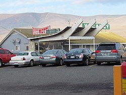
 Biggs Nu-Vu Motel | |
 Location of Biggs Junction, Oregon | |
| Coordinates: 45°39′50″N 120°50′21″W / 45.66389°N 120.83917°W | |
| Country | United States |
| State | Oregon |
| County | Sherman |
| Area | |
• Total | 0.89 sq mi (2.30 km2) |
| • Land | 0.89 sq mi (2.30 km2) |
| • Water | 0.00 sq mi (0.00 km2) |
| Elevation | 384 ft (117 m) |
| Population | |
• Total | 5 |
| • Density | 5.64/sq mi (2.18/km2) |
| Time zone | UTC-8 (Pacific (PST)) |
| • Summer (DST) | UTC-7 (PDT) |
| ZIP code | 97065 |
| Area codes | 458 and 541 |
| FIPS code | 41-06400[4] |
| GNIS feature ID | 2407848[2] |
Biggs Junction is an unincorporated community and census-designated place (CDP) in Sherman County, Oregon, United States.[2]
Biggs Junction is located on the south side of the Columbia River at the junction of Interstate 84/U.S. 30 and U.S. 97 where it crosses the Sam Hill Memorial Bridge over the river from Washington.[5] The population was 22 at the 2010 census.[6]
- ^ "ArcGIS REST Services Directory". United States Census Bureau. Retrieved October 12, 2022.
- ^ a b c U.S. Geological Survey Geographic Names Information System: Biggs Junction, Oregon
- ^ Cite error: The named reference
USCensusDecennial2020CenPopScriptOnlywas invoked but never defined (see the help page). - ^ "U.S. Census website". United States Census Bureau. Retrieved January 31, 2008.
- ^ Oregon Atlas & Gazetteer (7th ed.). Yarmouth, Maine: DeLorme. 2008. p. 72. ISBN 978-0-89933-347-2.
- ^ American FactFinder – Results[dead link]
Previous Page Next Page


