Our website is made possible by displaying online advertisements to our visitors.
Please consider supporting us by disabling your ad blocker.
Bourg-Argental
Bourg-Argental | |
|---|---|
Commune | |
 | |
| Coordinates: 45°17′50″N 4°33′38″E / 45.2972°N 4.5606°E | |
| Country | France |
| Region | Auvergne-Rhône-Alpes |
| Department | Loire |
| Arrondissement | Saint-Étienne |
| Canton | Le Pilat |
| Intercommunality | Monts du Pilat |
| Government | |
| • Mayor (2020–2026) | Stéphane Heyraud[1] |
Area 1 | 20.15 km2 (7.78 sq mi) |
| Population (2022)[2] | 2,920 |
| • Density | 140/km2 (380/sq mi) |
| Time zone | UTC+01:00 (CET) |
| • Summer (DST) | UTC+02:00 (CEST) |
| INSEE/Postal code | 42023 /42220 |
| Elevation | 450–1,003 m (1,476–3,291 ft) |
| 1 French Land Register data, which excludes lakes, ponds, glaciers > 1 km2 (0.386 sq mi or 247 acres) and river estuaries. | |
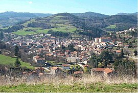
Bourg-Argental (French pronunciation: [buʁk‿aʁʒɑ̃tal] ⓘ; Arpitan: Lo Bôrg-Argentâf; Occitan: Lo Borg d'Argentau) is a commune in the Loire department in central France.
- ^ "Répertoire national des élus: les maires". data.gouv.fr, Plateforme ouverte des données publiques françaises (in French). 2 December 2020.
- ^ "Populations de référence 2022" (in French). The National Institute of Statistics and Economic Studies. 19 December 2024.
Previous Page Next Page


