Our website is made possible by displaying online advertisements to our visitors.
Please consider supporting us by disabling your ad blocker.
Bridgeton, Missouri
Bridgeton, Missouri | |
|---|---|
 Welcome sign, Bridgeton, July 2016 | |
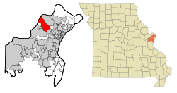
 Location of Bridgeton, Missouri | |
| Coordinates: 38°45′26″N 90°25′4″W / 38.75722°N 90.41778°W | |
| Country | United States |
| State | Missouri |
| County | St. Louis |
| Government | |
| • Mayor | Randy Hein |
| Area | |
• Total | 15.24 sq mi (90.00 km2) |
| • Land | 14.55 sq mi (37.69 km2) |
| • Water | 0.69 sq mi (1.77 km2) |
| Elevation | 541 ft (165 m) |
| Population (2020) | |
• Total | 11,445 |
| • Density | 786.44/sq mi (303.65/km2) |
| Time zone | UTC-6 (Central (CST)) |
| • Summer (DST) | UTC-5 (CDT) |
| Zip Code | 63044[3] |
| Area code(s) | 314/557 |
| FIPS code | 29-08398[4] |
| GNIS feature ID | 2393417[2] |
| Website | www |
Bridgeton is a second-ring suburb of Greater St. Louis in northwestern St. Louis County, Missouri, United States. Bridgeton is located at the intersection of the St. Louis outer belt and I-70. Bridgeton serves as the primary transport hub within Greater St. Louis. The population at the 2020 census was 11,445.[5] Portions of St. Louis Lambert International Airport are within Bridgeton.[6] The town is featured in the documentary Atomic Homefront, which covers the effects of radioactive waste stored in the nearby West Lake Landfill site.
- ^ "ArcGIS REST Services Directory". United States Census Bureau. Retrieved August 28, 2022.
- ^ a b U.S. Geological Survey Geographic Names Information System: Bridgeton, Missouri
- ^ "Bridgeton MO ZIP Code". zipdatamaps.com. 2023. Retrieved January 26, 2023.
- ^ "U.S. Census website". United States Census Bureau. Retrieved January 31, 2008.
- ^ "United States Census Bureau". Retrieved February 3, 2022.
- ^ "Bridgeton city, Missouri[permanent dead link]." U.S. Census Bureau. Retrieved on June 9, 2009.
Previous Page Next Page


