Our website is made possible by displaying online advertisements to our visitors.
Please consider supporting us by disabling your ad blocker.
Canton, Massachusetts
Canton, Massachusetts | |
|---|---|
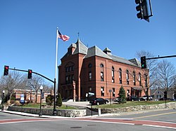
 Town Hall | |
 Location of Canton in Norfolk County | |
| Coordinates: 42°09′30″N 71°08′43″W / 42.15833°N 71.14528°W | |
| Country | |
| State | |
| County | Norfolk |
| Settled | 1630 |
| Incorporated | 1797 |
| Government | |
| • Type | Open town meeting |
| Area | |
• Total | 50.7 km2 (19.6 sq mi) |
| • Land | 49.0 km2 (18.9 sq mi) |
| • Water | 1.7 km2 (0.6 sq mi) |
| Elevation | 30 m (100 ft) |
| Population (2020)[1] | |
• Total | 24,370 |
| • Density | 497.3/km2 (1,289.4/sq mi) |
| Time zone | UTC−5 (Eastern) |
| • Summer (DST) | UTC−4 (Eastern) |
| ZIP Code | 02021 |
| Area code | 781/339 |
| FIPS code | 25-11315 |
| GNIS feature ID | 0619457 |
| Website | www.town.canton.ma.us |
Canton is a town in Norfolk County, Massachusetts, United States. The population was 24,370 at the 2020 census. Canton is part of Greater Boston, about 15 miles (24 kilometers) southwest of Downtown Boston.
- ^ "Census – Geography Profile: Canton town, Norfolk County, Massachusetts". U.S. Census Bureau. Retrieved November 3, 2021.
Previous Page Next Page


