Our website is made possible by displaying online advertisements to our visitors.
Please consider supporting us by disabling your ad blocker.
Carbrooke
| Carbrooke | |
|---|---|
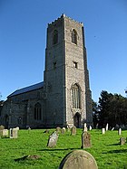
 Church of St. Peter and St. Paul | |
Location within Norfolk | |
| Area | 12.66 km2 (4.89 sq mi) |
| Population | 2,684 (2021 census) |
| • Density | 212/km2 (550/sq mi) |
| OS grid reference | TF9494002230 |
| District | |
| Shire county | |
| Region | |
| Country | England |
| Sovereign state | United Kingdom |
| Post town | Thetford |
| Postcode district | IP25 |
| Dialling code | 01953 |
| Police | Norfolk |
| Fire | Norfolk |
| Ambulance | East of England |
| UK Parliament | |
Carbrooke is a village and civil parish in the English county of Norfolk.
Carbrooke is located 2.1 miles (3.4 km) east of Watton, 13 miles (21 km) north-east of Thetford and 18 miles (29 km) west of Norwich.
Previous Page Next Page


