Our website is made possible by displaying online advertisements to our visitors.
Please consider supporting us by disabling your ad blocker.
Carlingford, New South Wales
| Carlingford Sydney, New South Wales | |||||||||||||||
|---|---|---|---|---|---|---|---|---|---|---|---|---|---|---|---|
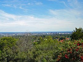
 The view from Mobbs Hill has been a noted feature of the district for generations | |||||||||||||||
 | |||||||||||||||
| Population | 28,044 (2021 census)[1] | ||||||||||||||
| • Density | 3,550/km2 (9,190/sq mi) | ||||||||||||||
| Postcode(s) | 2118 | ||||||||||||||
| Elevation | 129 m (423 ft) | ||||||||||||||
| Area | 7.9 km2 (3.1 sq mi) | ||||||||||||||
| Location | 22 km (14 mi) NW of Sydney CBD | ||||||||||||||
| LGA(s) | City of Parramatta | ||||||||||||||
| State electorate(s) | Epping | ||||||||||||||
| Federal division(s) | |||||||||||||||
| |||||||||||||||
Carlingford (/ˈkɑːrlɪŋfərd/) is a suburb of Sydney, in the state of New South Wales, Australia. Carlingford is 22 kilometres (14 mi) north-west of the Sydney central business district in the local government area of City of Parramatta. Carlingford sits at the meeting point of Northern Sydney[2] and Western Sydney sitting on both sides of Pennant Hills Road which generally acts as a divider of the two regions. While being part of City of Parramatta, it is sometimes referred to as being part of the Hills District.[3]
- ^ "2021 Carlingford, Census All persons QuickStats | Australian Bureau of Statistics". Archived from the original on 27 December 2022. Retrieved 27 December 2022.
- ^ School Operations and Performance (12 October 2020). "Metropolitan North". education.nsw.gov.au. Archived from the original on 10 August 2021. Retrieved 15 March 2021.
- ^ "Best Sydney Property Buyers' Agents, The Hills District". www.propertybuyer.com.au. Archived from the original on 25 February 2021. Retrieved 15 March 2021.
Previous Page Next Page


