Our website is made possible by displaying online advertisements to our visitors.
Please consider supporting us by disabling your ad blocker.
Cass City, Michigan
Cass City, Michigan | |
|---|---|
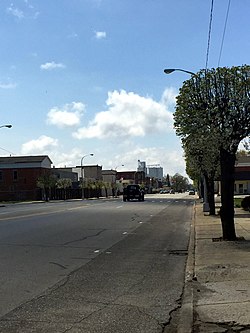
 Main Street (M-81), Cass City | |
| Motto: "each step in the right direction"[1] | |
 Location of Cass City, Michigan | |
| Coordinates: 43°35′58″N 83°10′35″W / 43.59944°N 83.17639°W | |
| Country | United States |
| State | Michigan |
| County | Tuscola |
| Township | Elkland |
| Named for | Cass River |
| Area | |
• Total | 1.77 sq mi (4.58 km2) |
| • Land | 1.76 sq mi (4.57 km2) |
| • Water | 0.01 sq mi (0.01 km2) |
| Elevation | 745 ft (227 m) |
| Population (2020) | |
• Total | 2,494 |
| • Density | 1,413.03/sq mi (545.69/km2) |
| Time zone | UTC-5 (Eastern (EST)) |
| • Summer (DST) | UTC-4 (EDT) |
| ZIP code | 48726 |
| Area code | 989 |
| FIPS code | 26-13880[3] |
| GNIS feature ID | 0622846[4] |
| Website | Village of Cass City, Michigan |
Cass City is a village in Elkland Township, Tuscola County in the Flint/Tri-Cities area of the U.S. state of Michigan. The population was 2,428 at the 2010 U.S. Census and 2,643 at the 2000 U.S. Census (a decrease of about 8%). It is located along M-81 approximately four miles (6.4 km) west of that highway's intersection with M-53. Cass City is surrounded by several communities including Colwood, Deford, Elmwood and Ellington.
- ^ "Village of Cass City, Michigan". Village of Cass City, Michigan. Retrieved August 25, 2012.
- ^ "2020 U.S. Gazetteer Files". United States Census Bureau. Retrieved May 21, 2022.
- ^ "U.S. Census website". United States Census Bureau. Retrieved January 31, 2008.
- ^ "US Board on Geographic Names". United States Geological Survey. October 25, 2007. Retrieved January 31, 2008.
Previous Page Next Page


