Our website is made possible by displaying online advertisements to our visitors.
Please consider supporting us by disabling your ad blocker.
Cheshire Bridge (Connecticut River)
Cheshire Bridge | |
|---|---|
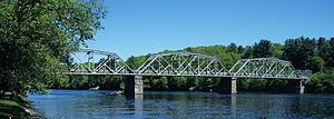
 1930 Cheshire Bridge over the Connecticut River | |
| Coordinates | 43°15′38″N 72°25′38″W / 43.260452°N 72.427319°W |
| Carries | 2 lanes of roadway trains (until 1984) |
| Crosses | Connecticut River |
| Characteristics | |
| Design | three-span Pennsylvania truss |
| Total length | 489 feet (149 m) |
| History | |
| Constructed by | McClintic-Marshall Co. |
| Construction end | 1806, 1906, 1930 |
| Construction cost | US$225,000 (US$4,100,000 with inflation[1]) |
| Opened | 1930 |
| Statistics | |
| Toll | none since 2001 |
| Location | |
 | |
The Cheshire Bridge spans the Connecticut River between Charlestown, New Hampshire, and Springfield, Vermont.[2][3]
- ^ 1634–1699: McCusker, J. J. (1997). How Much Is That in Real Money? A Historical Price Index for Use as a Deflator of Money Values in the Economy of the United States: Addenda et Corrigenda (PDF). American Antiquarian Society. 1700–1799: McCusker, J. J. (1992). How Much Is That in Real Money? A Historical Price Index for Use as a Deflator of Money Values in the Economy of the United States (PDF). American Antiquarian Society. 1800–present: Federal Reserve Bank of Minneapolis. "Consumer Price Index (estimate) 1800–". Retrieved February 29, 2024.
- ^ "Cheshire Bridge". Bridgehunter.com. Retrieved 9 August 2014.
- ^ John Farmer; Jacob Bailey Moore (1823). A gazetteer of the state of New-Hampshire, by J. Farmer and J.B. Moore. pp. 94–.
Previous Page Next Page


