Our website is made possible by displaying online advertisements to our visitors.
Please consider supporting us by disabling your ad blocker.
Clarence Valley Council
| Clarence Valley New South Wales | |||||||||||||||
|---|---|---|---|---|---|---|---|---|---|---|---|---|---|---|---|
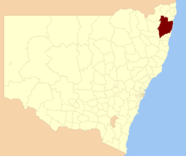
 Location in New South Wales | |||||||||||||||
| Population |
| ||||||||||||||
| • Density | 5.13983/km2 (13.3121/sq mi) | ||||||||||||||
| Established | 24 February 2004 | ||||||||||||||
| Area | 10,441 km2 (4,031.3 sq mi) | ||||||||||||||
| Mayor | Ray Smith[3] | ||||||||||||||
| Council seat | Grafton and Maclean | ||||||||||||||
| Region | Northern Rivers | ||||||||||||||
| State electorate(s) | Clarence[4] | ||||||||||||||
| Federal division(s) | Page[5] | ||||||||||||||
 | |||||||||||||||
| Website | Clarence Valley | ||||||||||||||
| |||||||||||||||
Clarence Valley Council is a local government area in the Northern Rivers region of New South Wales, Australia[6].
The council services an area of 10,441 square kilometres (4,031 sq mi) and draws its name from the Clarence River, which flows through most of the council area. The area under management is adjacent to the Pacific Highway, the Gwydir Highway and the North Coast railway line. The Clarence Valley region includes the coastal plain and lower valleys of the Clarence and Nymboida river. Most of the valley is agricultural; however, the oceanside towns of Yamba and Iluka are popular holiday resorts.[7]
The council was formed in February 2004 by the merger of the City of Grafton and Maclean Shire, and parts of Copmanhurst, Pristine Waters and Richmond Valley local government areas, and the activities of North Coast Water and Clarence River County Council.[8]
The mayor of Clarence Valley Council is Ray Smith.[3] The Deputy Mayor is Greg Clancy.[9]
- ^ Australian Bureau of Statistics (28 June 2022). "Clarence Valley (A)". 2021 Census QuickStats. Retrieved 7 July 2017.
- ^ "3218.0 – Regional Population Growth, Australia, 2017–18". Australian Bureau of Statistics. 27 March 2019. Retrieved 27 March 2019. Estimated resident population (ERP) at 30 June 2018.
- ^ a b "Cr Ray Smith". www.clarence.nsw.gov.au. Retrieved 31 January 2025.
- ^ "The Legislative Assembly District of Clarence". elections.nsw.gov.au. Retrieved 3 February 2025.
- ^ corporateName=Australian Electoral Commission; address=10 Mort Street, Canberra ACT 2600; contact=13 23 26. "Profile of the electoral division of Page (NSW)". Australian Electoral Commission. Retrieved 3 February 2025.
{{cite web}}: CS1 maint: multiple names: authors list (link) CS1 maint: numeric names: authors list (link) - ^ "Clarence Valley Council". elections.nsw.gov.au. Retrieved 3 February 2025.
- ^ "Clarence Valley Social Plan". Clarence Valley Council. Archived from the original on 10 February 2007. Retrieved 19 November 2006.
- ^ "About Council and the Clarence Valley". About Council. Clarence Valley Council. 2016. Retrieved 28 May 2016.
- ^ "Mayor and Councillors". www.clarence.nsw.gov.au. Retrieved 31 January 2025.
Previous Page Next Page


