Our website is made possible by displaying online advertisements to our visitors.
Please consider supporting us by disabling your ad blocker.
Clay Township, Hamilton County, Indiana
Clay Township | |
|---|---|
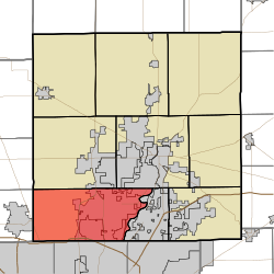
 Location in Hamilton County | |
| Coordinates: 39°57′48″N 86°08′54″W / 39.96333°N 86.14833°W | |
| Country | United States |
| State | Indiana |
| County | Hamilton |
| Settled | 1802 |
| Township organized | 1833 |
| Government | |
| • Type | Indiana township |
| Area | |
• Total | 50.18 sq mi (130.0 km2) |
| • Land | 49.09 sq mi (127.1 km2) |
| • Water | 1.09 sq mi (2.8 km2) 2.17% |
| Elevation | 843 ft (257 m) |
| Population | |
• Total | 99,093 |
| • Density | 2,014.1/sq mi (777.6/km2) |
| ZIP codes | 46032, 46033, 46074, 46077, 46082, 46260, 46280, 46290 |
| Area code(s) | 317, 463 |
| GNIS feature ID | 0453209 |
Clay Township is one of nine townships in Hamilton County, Indiana, United States. As of the 2010 census, its population was 83,293 and it contained 32,375 housing units.[2] Since the annexation of Home Place, Indiana, Carmel is now completely coterminous with the township.[3]
- ^ "Census Bureau profile: Clay Township, Hamilton County, Indiana". United States Census Bureau. May 2023. Retrieved March 18, 2024.
- ^ "Population, Housing Units, Area, and Density: 2010 - County -- County Subdivision and Place -- 2010 Census Summary File 1". United States Census. Archived from the original on February 12, 2020. Retrieved May 10, 2013.
- ^ "Home Place annexation begins today • Current Publishing". March 2018.
Previous Page Next Page


