Our website is made possible by displaying online advertisements to our visitors.
Please consider supporting us by disabling your ad blocker.
Dapoli
This article needs additional citations for verification. (September 2015) |
Dapoli | |
|---|---|
Rural Area Of Konkan Region | |
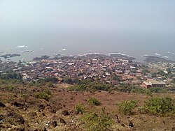
 View of Pajpandhari, Dapoli | |
Location in Maharashtra, India | |
| Coordinates: 17°45′32″N 73°11′8″E / 17.75889°N 73.18556°E | |
| Country | |
| State | Maharashtra |
| District | Ratnagiri |
| Government | |
| • Type | Municipal Council |
| • Body | Dapoli Municipal Council |
| Area | |
• Total | 26.11 km2 (10.08 sq mi) |
| Elevation | 243.84 m (800.00 ft) |
| Population (2011)[1] | |
• Total | 34,544 |
| • Density | 1,300/km2 (3,400/sq mi) |
| Demonym | Dapolikar |
| Language | |
| • Official | Marathi |
| Time zone | UTC+5:30 (IST) |
| PIN | 415712 |
| Telephone code | 02358 |
| Vehicle registration | MH-08 |
| Nearest town | Khed |
Dapoli is a Village and taluka in the Ratnagiri district of Maharashtra, India. It lies 215 km (134 mi) south of the state capital of Mumbai. The town is also known as Camp Dapoli, as the British had set their camps here. Many high-ranking British officers' graves are found in this town. There is also an abandoned church from the time of the British Raj. Dapoli was administered by a Municipal Council.

Previous Page Next Page


