Our website is made possible by displaying online advertisements to our visitors.
Please consider supporting us by disabling your ad blocker.
Derrimut, Victoria
| Derrimut Melbourne, Victoria | |||||||||||||||
|---|---|---|---|---|---|---|---|---|---|---|---|---|---|---|---|
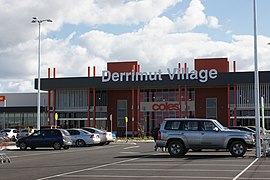
 Derrimut Village | |||||||||||||||
 | |||||||||||||||
| Coordinates | 37°47′42″S 144°45′58″E / 37.795°S 144.766°E | ||||||||||||||
| Population | 8,651 (2021 census)[1] | ||||||||||||||
| • Density | 665/km2 (1,720/sq mi) | ||||||||||||||
| Postcode(s) | 3026 | ||||||||||||||
| Area | 13 km2 (5.0 sq mi) | ||||||||||||||
| Location | 17 km (11 mi) from Melbourne | ||||||||||||||
| LGA(s) | City of Brimbank | ||||||||||||||
| State electorate(s) | Kororoit | ||||||||||||||
| Federal division(s) | |||||||||||||||
| |||||||||||||||
Derrimut (/ˈdɛrɪmət/ ⓘ DERR-im-ət) is a suburb in Melbourne, Victoria, Australia, 17 km (11 mi) west of Melbourne's Central Business District, located within the City of Brimbank Local government area. Derrimut recorded a population of 8,651 at the 2021 census.[1]
Derrimut is a newly developed suburb in Melbourne. It is named after Derrimut, a nineteenth-century Aboriginal Elder. Derrimut is bounded by Foleys Road to the north, Robinsons Road to the west, the Western Ring Road to the east and Boundary Road to the south. Derrimut was once part of Deer Park, but was detached from the latter in 1998.[2]
- ^ a b Australian Bureau of Statistics (28 June 2022). "Derrimut (Suburbs and Localities)". 2021 Census QuickStats. Retrieved 19 July 2022.
- ^ "Deer Park | Victorian Places". www.victorianplaces.com.au. Retrieved 7 February 2025.
Previous Page Next Page


