Our website is made possible by displaying online advertisements to our visitors.
Please consider supporting us by disabling your ad blocker.
Falls City, Texas
Falls City, Texas | |
|---|---|
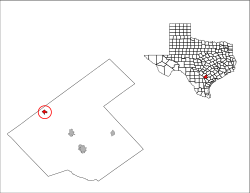
 Location of Falls City, Texas | |
 | |
| Coordinates: 28°59′N 98°1′W / 28.983°N 98.017°W | |
| Country | United States |
| State | Texas |
| County | Karnes |
| Area | |
• Total | 0.91 sq mi (2.36 km2) |
| • Land | 0.89 sq mi (2.31 km2) |
| • Water | 0.02 sq mi (0.05 km2) |
| Elevation | 308 ft (94 m) |
| Population (2020) | |
• Total | 514 |
| • Density | 772.42/sq mi (298.18/km2) |
| Time zone | UTC-6 (Central (CST)) |
| • Summer (DST) | UTC-5 (CDT) |
| ZIP code | 78113 |
| Area code | 830 |
| FIPS code | 48-25392[2] |
| GNIS feature ID | 1357209[3] |
Falls City is a city in Karnes County, Texas, United States. The population was 514 at the 2020 census.[4] Falls City is near the location of a uranium tailings disposal cell, completed in 1994 under the terms of the 1978 Uranium Mill Tailings Radiation Control Act.[5] The early settlers, predominantly Polish Catholics, founded the Holy Trinity Catholic Church in 1902.
- ^ "2019 U.S. Gazetteer Files". United States Census Bureau. Retrieved August 7, 2020.
- ^ "U.S. Census website". United States Census Bureau. Retrieved January 31, 2008.
- ^ "US Board on Geographic Names". United States Geological Survey. October 25, 2007. Retrieved January 31, 2008.
- ^ "Geographic Identifiers: 2010 Census Summary File 1 (G001), Falls City city, Texas". American FactFinder. U.S. Census Bureau. Archived from the original on February 13, 2020. Retrieved April 17, 2019.
- ^ "Falls City, Texas, Disposal Site Fact Sheet" (PDF). U.S. Department of Energy. April 5, 2009. Archived from the original (PDF) on April 6, 2021. Retrieved November 9, 2009.
Previous Page Next Page


