Our website is made possible by displaying online advertisements to our visitors.
Please consider supporting us by disabling your ad blocker.
Forehoe and Henstead Rural District
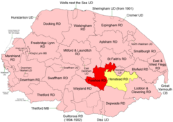
 Boundaries in 1894. Forehoe RD in red, Henstead RD yellow. |
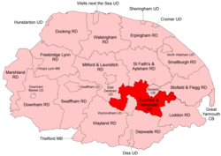
 Boundaries in 1935 |
Forehoe and Henstead Rural Districts were adjacent rural districts in Norfolk, England from 1894 to 1935.[1][2]
They were formed under the Local Government Act 1894 based on rural sanitary districts of the same names, and lay generally south of Norwich.
In 1935 the Wymondham parish of Forehoe RD was created a new Wymondham Urban District. The remainder, together with the whole of Henstead RD apart from an island in the River Yare, were merged to form Forehoe and Henstead Rural District.[3] Subsequently, changes to the border with Norwich County Borough were made in 1968.
In 1974, the merged district was abolished under the Local Government Act 1972, and became part of the South Norfolk district.
- ^ "Forehoe RD through time: Census tables with data for the Local Government District". A Vision of Britain through Time. GB Historical GIS / University of Portsmouth. Retrieved 1 July 2017.
- ^ "Henstead RD through time: Census tables with data for the Local Government District". A Vision of Britain through Time. GB Historical GIS / University of Portsmouth. Retrieved 1 July 2017.
- ^ "Forehoe and Henstead RD through time: Census tables with data for the Local Government District". A Vision of Britain through Time. GB Historical GIS / University of Portsmouth. Retrieved 1 July 2017.
Previous Page Next Page


