Our website is made possible by displaying online advertisements to our visitors.
Please consider supporting us by disabling your ad blocker.
Gramos
| Gramos | |
|---|---|
| Gramoz | |
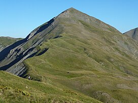
 View of the southern face of Gramoz | |
| Highest point | |
| Elevation | 2,523 m (8,278 ft) |
| Prominence | 1,303 m (4,275 ft)[1] |
| Isolation | 1.4 km (0.87 mi) |
| Listing | Ribu |
| Coordinates | 40°27′45″N 20°55′54″E / 40.462562°N 20.931761°E |
| Geography | |
| Countries | |
| Region | Southern Mountain Region |
| Municipality | Kolonjë, Konitsa, Nestorio |
| Parent range | Moravë-Mali i Vashës |
| Geology | |
| Rock age | Paleogene |
| Mountain type | mountain chain |
| Rock type(s) | flysch, limestone |
Gramos (Greek: Γράμος or Γράμμος; Albanian: Gramoz, Mali i Gramozit; Aromanian: Gramosta, Gramusta, Yramos or Yramustea) is a mountain chain situated on the border of Albania and Greece. Part of the larger northern Pindus mountain range, its highest peak, Maja e Çukapeçit, rises at an elevation of 2,523 m (8,278 ft).[2]
Previous Page Next Page


