Our website is made possible by displaying online advertisements to our visitors.
Please consider supporting us by disabling your ad blocker.
Grindel Point Light
 | |
 | |
| Location | Ferry Rd., Islesboro, Maine |
|---|---|
| Coordinates | 44°16′53.151″N 68°56′34.997″W / 44.28143083°N 68.94305472°W |
| Tower | |
| Constructed | 1850 |
| Automated | 1934 |
| Height | 12 m (39 ft) |
| Shape | Square Tower |
| Markings | White |
| Heritage | National Register of Historic Places listed place |
| Fog signal | Bell originally None now |
| Light | |
| First lit | 1874 (current structure) |
| Deactivated | 1934-1987 |
| Focal height | 39 feet (12 m) |
| Lens | 5th order Fresnel lens (original), 9.8 inches (250 mm) (current) |
| Range | 4 nautical miles (7.4 km; 4.6 mi) |
| Characteristic | Fl G 4s |
Grindel Point Light Station | |
| Built | 1874 |
| NRHP reference No. | 87000427[1] |
| Added to NRHP | March 13, 1987 |
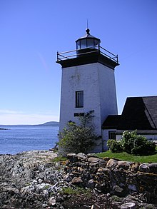
Grindel Point Light is a lighthouse in Islesboro, Maine, marking the west entrance to Gilkey Harbor at the westernmost point of the eponymous island.[2][3] The light station was established in 1850, and the present tower and keeper's house were built in 1874. The station was deactivated in 1934 and reactivated in 1987. It was listed on the National Register of Historic Places in 1987.[1] The keeper's house now houses the Grindel Point Sailor's Museum and the lighthouse tower is open for tours in the summer.
- ^ a b "National Register Information System". National Register of Historic Places. National Park Service. March 13, 2009.
- ^ "Historic Light Station Information and Photography: Maine". United States Coast Guard Historian's Office. August 6, 2009. Archived from the original on May 1, 2017.
- ^ United States Coast Guard (2009). Light List, Volume I, Atlantic Coast, St. Croix River, Maine to Shrewsbury River, New Jersey. p. 39.
Previous Page Next Page


