Our website is made possible by displaying online advertisements to our visitors.
Please consider supporting us by disabling your ad blocker.
Hanbury Street
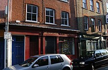
 South side of Hanbury Street, showing 28 and 30 | |
| Former name(s) | Browne's Lane |
|---|---|
| Length | 0.5 mi (0.80 km)[1] |
| Location | Tower Hamlets |
| Postal code | E1 |
| Nearest train station | |
| west end | 51°31′13″N 0°04′28″W / 51.5203°N 0.0744°W |
| east end | Old Montague Street 51°31′11″N 0°03′50″W / 51.5197°N 0.0639°W |
Hanbury Street is a street running from Commercial Street in Spitalfields to the junction of Old Montague Street and Vallance Road in Whitechapel located in the London Borough of Tower Hamlets. The eastern section is restricted to pedal cycles and pedestrians only.
- ^ "Walking directions to Hanbury St". Retrieved 6 October 2013.
Previous Page Next Page


