Our website is made possible by displaying online advertisements to our visitors.
Please consider supporting us by disabling your ad blocker.
Hay, New South Wales
| Hay New South Wales | |||||||||
|---|---|---|---|---|---|---|---|---|---|
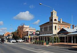
 Looking south down Lachlan Street, the main street of Hay | |||||||||
| Coordinates | 34°30′0″S 144°51′0″E / 34.50000°S 144.85000°E | ||||||||
| Population | 2,882 (2021 census)[1] | ||||||||
| Established | 1859 | ||||||||
| Postcode(s) | 2711 | ||||||||
| Elevation | 93.3 m (306 ft) | ||||||||
| Location | |||||||||
| LGA(s) | Hay Shire | ||||||||
| County | Waradgery | ||||||||
| State electorate(s) | Murray | ||||||||
| Federal division(s) | Farrer | ||||||||
| |||||||||
Hay is a town in the western Riverina region of south-western New South Wales, Australia. It is the administrative centre of Hay Shire local government area and the centre of a prosperous and productive agricultural district on the wide Hay Plains.
Located approximately midway between Sydney and Adelaide at the junction of the Sturt, Cobb and Mid-Western Highways, Hay is an important regional and national transport node. The town itself is built beside the Murrumbidgee River, part of the Murray–Darling river system; Australia's largest. The main business district of Hay is situated on the north bank of the river.
Previous Page Next Page


