Our website is made possible by displaying online advertisements to our visitors.
Please consider supporting us by disabling your ad blocker.
Ibrahimpatnam
Ibrahimpatnam | |
|---|---|
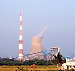
 Vijayawada Thermal Power Station (VTPS), Ibrahimpatnam | |
 Interactive map | |
| Coordinates: 16°36′20″N 80°22′3″E / 16.60556°N 80.36750°E | |
| Country | |
| State | Andhra Pradesh |
| Region | Coastal Andhra |
| District | NTR |
| Mandal | Ibrahimpatnam mandal |
| City | Vijayawada |
| Metropolitan Area | Andhra Pradesh Capital Region |
| Area | |
• Total | 15.00 km2 (5.79 sq mi) |
| Elevation | 27 m (89 ft) |
| Population (2011) | |
• Total | 29,432 |
| • Density | 2,000/km2 (5,100/sq mi) |
| Time zone | UTC+5:30 (IST) |
| PIN | 521456 |
| Telephone code | +91–866 |
Ibrahimpatnam (known locally as IBM) is a part of Vijayawada in NTR district of the Indian state of Andhra Pradesh. It is also the mandal headquarters of Ibrahimpatnam mandal.[1][2] The Dr Narla Tata Rao Thermal Power Station, one of the major thermal power stations of the state, is located near the town.[3] The Railway Wagon Workshop at Rayanapadu is also located very near to Ibrahimpatnam at a distance of 4 km.
- ^ "Krishna District Mandals" (PDF). Census of India. pp. 492, 526. Retrieved 21 January 2015.
- ^ "District Census Handbook - Krishna" (PDF). Census of India. pp. 16–17, 48. Retrieved 18 January 2015.
- ^ "Dr. Narla Tata Rao Thermal Power Station". Andhra Pradesh Generation Corporation Limited. Archived from the original on 14 January 2015. Retrieved 14 January 2015.
Previous Page Next Page


