Our website is made possible by displaying online advertisements to our visitors.
Please consider supporting us by disabling your ad blocker.
Kiska
Native name: Qisxa | |
|---|---|
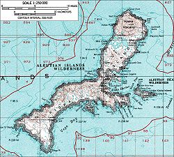
 A topographical map of Kiska | |
 | |
| Geography | |
| Coordinates | 51°57′51″N 177°27′36″E / 51.96417°N 177.46000°E |
| Archipelago | Rat Islands group of the Aleutian Islands |
| Area | 107.22 sq mi (277.7 km2) |
| Length | 22 mi (35 km) |
| Width | 1.5 mi (2.4 km) - 6 mi (10 km) |
| Highest elevation | 4,004 ft (1220.4 m) |
| Highest point | Kiska Volcano |
| Administration | |
United States | |
| State | Alaska |
| Census Area | Aleutians West Census Area |
| Demographics | |
| Population | 0 (2010) |

Kiska (Aleut: Qisxa,[1] Russian: Кыска) is one of the Rat Islands, a group of the Aleutian Islands of Alaska. It is about 22 miles (35 km) long and varies in width from 1.5 to 6 miles (2.4 to 9.7 km). It is part of Aleutian Islands Wilderness and as such, special permission is required to visit it.[2] The island has no permanent population.
- ^ Bergsland, K. (1994). Aleut Dictionary. Fairbanks: Alaska Native Language Center.
- ^ Sommers, Carl (November 25, 1990). "Q and A: Visiting the Aleutians". The New York Times. Retrieved August 25, 2014.
Previous Page Next Page


