Our website is made possible by displaying online advertisements to our visitors.
Please consider supporting us by disabling your ad blocker.
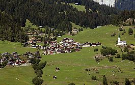
Ladir
Ladir | |
|---|---|
 | |
| Coordinates: 46°47′N 9°12′E / 46.783°N 9.200°E | |
| Country | Switzerland |
| Canton | Graubünden |
| District | Surselva |
| Area | |
• Total | 7.19 km2 (2.78 sq mi) |
| Elevation | 1,276 m (4,186 ft) |
| Population (Dec 2011) | |
• Total | 115 |
| • Density | 16/km2 (41/sq mi) |
| Time zone | UTC+01:00 (Central European Time) |
| • Summer (DST) | UTC+02:00 (Central European Summer Time) |
| Postal code(s) | 7155 |
| SFOS number | 3576 |
| ISO 3166 code | CH-GR |
| Surrounded by | Falera, Ruschein, Schluein, Schnaus |
| Website | www SFSO statistics |
Ladir is a former municipality in the district of Surselva in the Swiss canton of Graubünden. On 1 January 2014 the former municipalities of Ladir, Castrisch, Ilanz, Luven, Pitasch, Riein, Ruschein, Schnaus, Sevgein, Duvin, Pigniu, Rueun and Siat merged into the new municipality of Ilanz/Glion.[1]
- ^ Nomenklaturen – Amtliches Gemeindeverzeichnis der Schweiz (in German) accessed 13 December 2014
Previous Page Next Page


