Our website is made possible by displaying online advertisements to our visitors.
Please consider supporting us by disabling your ad blocker.
Lake Bandung
| Lake Bandung | |
|---|---|
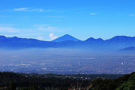
 The site of which lake Bandung used to be filled is now the Bandung Basin. | |
| Coordinates | 6°55′26″S 107°36′23″E / 6.92389°S 107.60639°E |
| Type | former lake |
| Surface elevation | 725 metres (2,379 ft) |
Lake Bandung (Sundanese: Situ Hiang) was a prehistoric lake located in and around the city of Bandung, Parahyangan highlands, West Java, Indonesia. believed to exist between 126,000 and 20,000 BCE in the Pleistocene due to the violent eruption of Mount Sunda that blocked the Citarum River, causing the lowlands to begin to be inundated with water, eventually forming a lake.[1]
Today, the lake had dried out and revealed the bottom of a geological basin known as the Bandung basin.[2] It is mostly filled with habitation and industrial areas, paddy fields and orchards. It is believed that this low-lying basin has caused the southern suburbs of Bandung to suffer seasonal flooding during the rainy season, as the Citarum river that formed the lowermost backbone of the basin overwhelms and swells.
- ^ Bagaskara, Bima. "Riwayat Gunung Sunda Purba: Letusannya Lahirkan Cekungan Bandung". detikjabar (in Indonesian). Retrieved 2022-12-23.
- ^ Tim Penulis Ekspedisi Cincin Api (12 April 2012). "Mangkuk Purba Cekungan Bandung". Kompas (in Indonesian). Retrieved 17 November 2014.
Previous Page Next Page


